Graduate research · Montana State University LRES

From coursework to a capstone question.

Dodge City routes stormwater to the Arkansas River while the Ogallala Aquifer remains under pressure. This research asks whether a portion of that runoff could be captured, retained locally, and routed by gravity to locations suitable for further recharge evaluation.

Capstone

The capstone in four steps.

Arkansas River Stormwater leaves town down the riverhighlighted: the reach below Dodge City A — northA′ — south Study focus: north bankschematic · no site selected SpearvilleBucklinFordWrightDodge City 5 mi N
Ford County, Kansas. Shaded relief from real elevation. The hillshade is exaggerated 30× so the relief is visible in flat country.
Elevation: Terrain Tiles (USGS 3DEP) · County boundary: U.S. Census Bureau TIGER · River: USGS National Hydrography Dataset · Grid: illustrative one-mile spacing, not surveyed section lines.
01 — The regional problem

Water leaves town while the aquifer declines.

Dodge City routes stormwater to the Arkansas River. The Ogallala Aquifer under the same town remains under pressure.

The capstone starts from that mismatch. The city manages runoff as a drainage problem at the surface while the region has a supply problem underground.
02 — The relevant observations

Start with what the ground does.

Ford County is flat, but it is not featureless. The Arkansas River valley cuts a shallow trench through it, and that small amount of relief decides where water can move without a pump.

The groundwater context comes from public records, including mapped depth-to-water ranges, diversion points, and monitoring references. I published those on this site as a dated snapshot.

Open the depth-to-water map

03 — The analytical method

A planning-scale GIS screen.

The capstone is a GIS feasibility study that is still in development. It asks whether stormwater could be captured, held locally, and routed by gravity to ground that could accept recharge.

The coursework builds the pieces. ERTH 524 covers runoff, infiltration, and recharge. LRES 507 applies the EPA four-step risk framework to urban-runoff pathways and groundwater receptors. The courses still ahead of me add watershed hydrology, modeling, soils, remote sensing, natural resource law, and water quality.

04 — The useful output

What the screen will and will not say.

The project is a planning-scale GIS feasibility screen. It should show where the idea deserves a closer look and where it does not.

It is not an engineered design, permit application, or construction proposal. No basin has been approved, permitted, or built. Field infiltration, routing and elevation, water quality, parcel and site questions, and regulatory questions are all still open.

Section A–A′: how flat is flat?

North–south elevation profile through Dodge City Ground elevation along longitude 100.0171° W from 37.98° N to 37.5° N, about 33 miles. Elevation ranges from about 2,450 to 2,662 feet, crossing the Arkansas River valley at Dodge City. Vertical exaggeration 167 times. 2,4002,4502,5002,5502,6002,6502,700 051015202530 Arkansas River valley Dodge City A — northA′ — south Distance along transect (miles) Elevation (ft)
Ground elevation along 33.2 miles north to south through Dodge City, from about 2,450 to 2,662 ft. Vertical exaggeration ≈ 167×. Drawn at true scale, this line would look level. Source: Terrain Tiles (USGS 3DEP), sampled at about 120 m. Ground surface only; nothing below the surface is shown.

Timeline

Coursework → capstone pipeline.

Terms and statuses are current as of November 2026. I am enrolled in the Spring 2027 courses, and the later terms are my proposed schedule. Course descriptions for the upcoming terms are condensed from Montana State’s course pages.

  1. LRES 505Summer 2026Complete

    Concepts of GIS in Environmental Science

    For the final project I studied solar siting suitability in Ford County. I combined transmission proximity, land cover, slope, and road proximity in a weighted MCDA overlay and tested it across five weighting scenarios.

    Question
    Where does utility-scale solar make the most sense in Ford County, and how much does the answer depend on the weights?
    Method
    Weighted overlay MCDA in QGIS with a five-scenario sensitivity analysis.
    Artifact
    Read the study. This is the full study with maps, methods, and references.
  2. ERTH 524Fall 2026In progress

    Earth System Science

    This course covers runoff, infiltration, and aquifer recharge, and it puts a lot of weight on explaining Earth systems to other people. I am using it to work out how to explain the capstone to people who do not work in GIS or hydrology.

    Question
    How do you explain where rain goes, and why so little of it reaches an aquifer, to someone who has never opened a GIS?
    Method
    Earth-system framing and science communication.
    Artifact
    I have not published a paper. Related teaching tools on this site: Water Budget Explorer, StrataProfile
  3. LRES 507Fall 2026In progress

    Environmental Risk Assessment

    My term project lays groundwork for the capstone. It uses the EPA four-step risk framework to screen urban-runoff pathways, potential recharge, and groundwater receptors.

    Question
    If urban runoff were recharged, what could travel with it, by which pathways, and to which receptors?
    Method
    The EPA four-step risk assessment framework applied as a screening exercise.
    Artifact
    Nothing published yet
  4. ERTH 519Spring 2027Enrolled

    Watershed Hydrology for Teachers

    This course covers watershed hydrology and how it relates to water quality and water quantity. Topics include how water inputs and outputs are measured, how human changes to a watershed affect surface and groundwater flow, and how to find and work with online water data. It is written for science teachers, so students also build lesson plans.

    Why I am taking it
    The capstone depends on how a town changes the path of its runoff, and this course covers that subject directly.
  5. LRES 546Spring 2027Enrolled

    Quantitative Methods Environmental

    This course builds quantitative analysis and modeling skills in watershed and environmental science. Students learn to describe how a model works, judge models of different types and complexity, and write code to analyze and simulate watershed processes.

    Why I am taking it
    A feasibility screen is a model, and I will need to be able to defend how mine is built.
  6. LRES 532Fall 2027Planned

    Soil Ecosystems and Processes

    This course covers the biological and non-biological processes in the soil ecosystem, with more weight on the biological ones. It includes nutrient and carbon cycling and the effects of human activity and disturbance on how soil functions.

    Why I am taking it
    Recharge water has to pass through soil before it reaches an aquifer.
  7. LRES 573Fall 2027Planned

    Remote Sensing Applications in Environmental Science

    This course covers the basics of remote sensing so that students can read its environmental applications critically. It combines textbook and journal readings, online discussion, and hands-on exercises in digital image processing and analysis.

    Why I am taking it
    I expect to use imagery for land cover and surface conditions in the capstone.
  8. LRES 530Spring 2028Planned

    Natural Resource Law

    This course examines the major natural resource laws, with an emphasis on the federal model. It uses case studies to review the legislation and court cases that govern water, minerals, timber, range, wildlife, recreation, and wilderness.

    Why I am taking it
    Capturing and recharging water raises legal questions that a GIS screen cannot answer. I want to know what those questions are before I write the paper.
  9. LRES 544Spring 2028Planned

    Water Quality

    This course covers the physical, biological, and chemical fundamentals of water quality along with the policy and management side. Topics include the legal framework for water quality management in the United States, calculating concentrations and loads, and the pitfalls of monitoring individual parameters.

    Why I am taking it
    Stormwater carries whatever is on the street. Water quality is one of the open questions in the capstone.
  10. LRES 575Fall 2028Capstone

    Stormwater Capture & Recharge Feasibility

    Dodge City routes stormwater to the Arkansas River while the Ogallala Aquifer remains under pressure. My capstone asks whether a portion of that runoff could be captured, retained locally, and routed by gravity to locations suitable for further recharge evaluation.

    Course
    LRES 575 is the Professional Paper and Project. Montana State describes it as an original project carried from design through completion, written to the standard of a peer-reviewed journal paper at roughly 25 to 45 double-spaced pages. It also requires an oral presentation by webinar to the graduate committee, and it is meant to build on the coursework that came before it.
    Question
    Could a portion of Dodge City’s stormwater be captured, retained locally, and routed by gravity to locations suitable for recharge?
    Method
    A planning-scale GIS feasibility screen, still in development.
    Artifact
    Nothing published yet

Limits

What this research does not claim.

  • The project is a planning-scale GIS feasibility screen. It is not an engineered design, permit application, or construction proposal.
  • No basin is approved, permitted, built, or operating.
  • Field infiltration, routing and elevation, water quality, site, and regulatory questions remain open.
  • I have not published a prospectus or paper for the capstone.
  • The relief, the river, the county boundary, and the elevation profile on this page are real data. The hatched north-bank band is schematic, and it is labeled that way.

Completed study

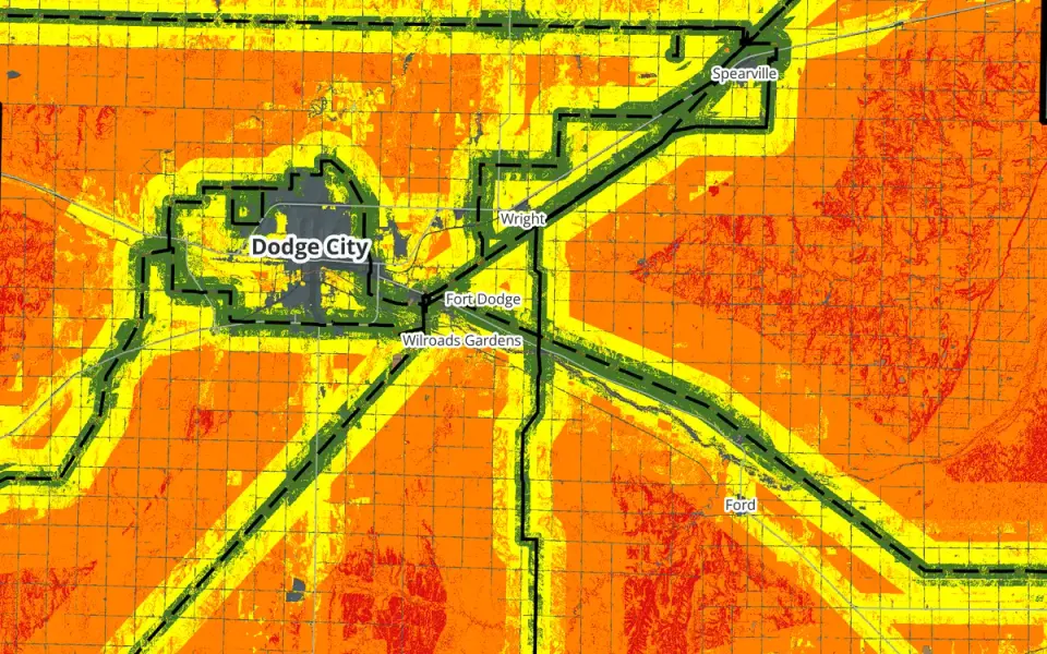
Baseline solar siting suitability map of Ford County: green high-suitability bands following transmission lines across orange and yellow farmlandResearch

Research · LRES 505 · Ford County, Kansas

Flat Out Suitable

A county-scale solar siting suitability study for Ford County. I weighted four factors, ran five weighting scenarios, and found that the answer depends heavily on transmission access.

Read

Tools and maps that explain the pieces

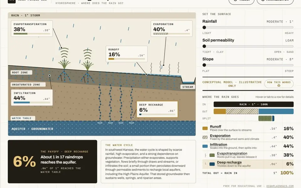
Water Budget Explorer: a cutaway hillslope showing rain splitting into runoff, evaporation, infiltration, and deep rechargeApp

Browser tool · hydrology teaching model

Water Budget Explorer

A conceptual hydrology teaching tool that shows how rainfall is partitioned among runoff, evaporation, and infiltration under different soil and slope conditions. It is an illustrative model, not a site-calibrated analysis.

Open
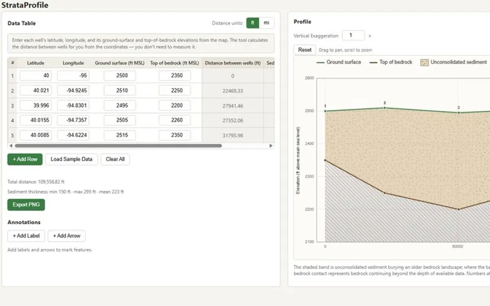
StrataProfile: a well data table above a drawn geologic cross-sectionApp

Browser tool · geology

StrataProfile

A browser tool that converts well-location and elevation records into a geologic cross-section. It calculates well spacing and sediment thickness while displaying the profile and source values together.

Open
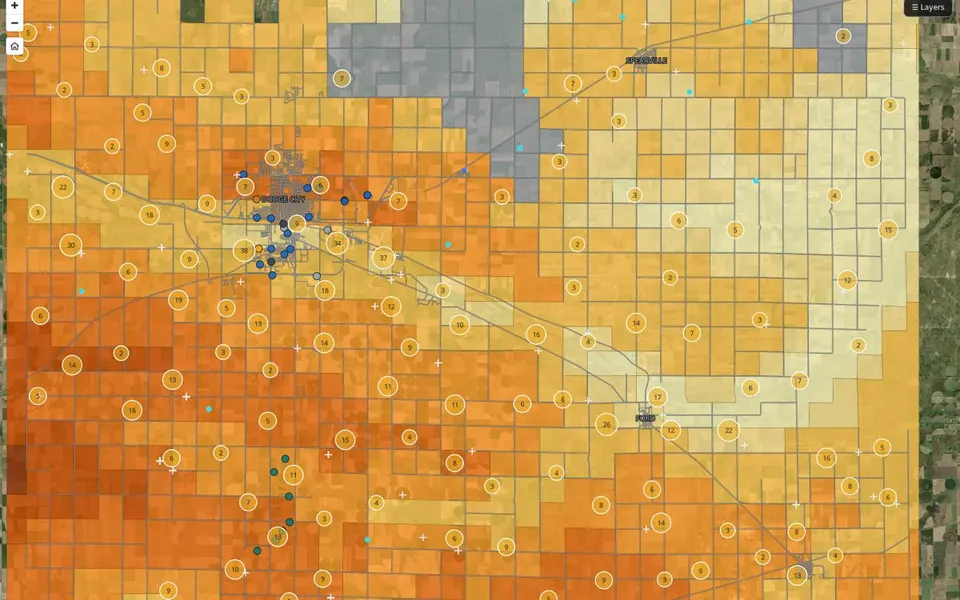
Ford County depth-to-water map: orange-to-cream section tiles with clustered diversion points around Dodge City, Spearville and FordMap

Public map · Ford County, Kansas

Depth to Water & Active Diversions

A public reference map of Ford County groundwater. It shows mapped depth-to-water ranges, active WIMAS diversion points, monitoring well references, and Dodge public-water wells.

Open

Contact

Do you work on recharge, stormwater, or the Ogallala?

↑↓ moveEnter openEsc close